About PeakVisor - 3D Maps & Peaks ID
PeakVisor will make you a superhero of outdoors navigation by putting state-of-the-art 3D maps and mountain identification in the palm of your hand. "PeakVisor is a seemingly magical app that instantly recognizes the name...
PeakVisor will make you a superhero of outdoors navigation by putting state-of-the-art 3D maps and mountain identification in the palm of your hand.
"PeakVisor is a seemingly magical app that instantly recognizes the name of any mountain peak that comes into view using a combination of your phone’s camera" - Atlas & Boots
"A lovely little app that uses your phone’s camera and the power of augmented reality to identify any mountain you aim the camera at." - Digital Trends
Key Features:
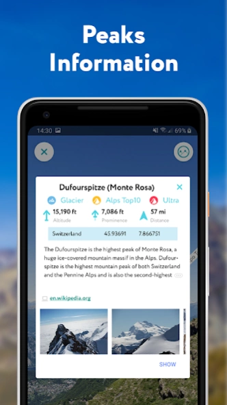
● Mountains Identification
Identify more than a million hills & mountains all over the world and get a detailed profile for each one of them, including altitude, topographic prominence, mountain range, what national parks or reserves it may belong to, as well as photos and Wikipedia articles. It is one of the most useful Augmented Reality technology applications on the market today.
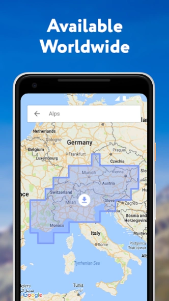
● 3D Maps
Get your topo maps of the future. Cutting edge technology with high-precision terrain modeling allows simple, yet effective insight into the landscape of the mountains. It is the most convenient way to explore a mountainous area, its trails, summits, passes, viewpoints, and even parking areas.
● Hiking Route Planner
A vast network of worldwide hiking trails and walking pathways included in PeakVisor’s 3D Maps will help you compose a hiking route, which includes, evaluating the distance you can expect to hike, as well as a route’s elevation profile, and estimated time for completion. To help you plan your route we’ve included points of interest in our 3D Maps such as mountain huts, parking lots, cable cars, viewpoints, castles, etc.
● Everything works Offline
Internet connection is not a prerequisite for the PeakVisor app. All the data is downloadable and ready for use no matter where you are or what altitude you might be at.
● Identifying Mountains in Photos
If you have photos from previous hikes that you did not take through the app, you can still find out what peaks you saw by download your images into the PeakVisor app and adding a digital overlay of the mountains with names and altitudes of all the peaks in view.
● Photo Planning
PeakVisor’s Sun and Moon trajectories come super handy when planning the perfect time to take pictures.
PeakVisor is the Swiss army knife of outdoor adventure and will soon be indispensable to you future hiking needs. Just keep it in your backpack and you'll get value from it every time you’re on the trail!
If you have any questions or just feel like talking about mountains, please contact us at
[email protected]
Previous Versions
Here you can find the changelog of PeakVisor - 3D Maps & Peaks ID since it was posted on our website on 2018-03-20 04:31:09.
The latest version is 2.8.59 and it was updated on 2024-04-22 08:44:14. See below the changes in each version.
PeakVisor - 3D Maps & Peaks ID version 2.8.59
Updated At: 2024-04-04
Changes: Join our worldwide peak bagging challenge. Collect summits, passes, mountain huts, and lakes. Keep your travel logbook up to date and unlock achievements no matter where you are.
PeakVisor - 3D Maps & Peaks ID version 2.8.0
Updated At: 2022-02-14
Changes: Meet PeakVisor widget! Get useful and interesting mountain data right on your home screen.
PeakVisor - 3D Maps & Peaks ID version
Updated At: 2021-09-17
Changes: Mountains are calling! Navigate hiking trails in 3D maps and identify even the smallest peaks with PeakVisor. Be a superhero of the outdoors. New in this version the very first version of GPS tracks support (let’s call it beta):
* GPX tracks import and export - download the best itineraries all over the world and follow them in 3D maps, share your routes with others
* Hiking GPS tracker - record your adventures and see them in real 3D (see the scale and grandeur of your epic hikes)
PeakVisor - 3D Maps & Peaks ID version
Updated At: 2021-06-04
Changes: Travel Logbook is here! Collect all your outdoor achievements with the PeakVisor app! Go out, have some fun, and check-in on mountains, passes, near lakes, and mountain huts.
PeakVisor - 3D Maps & Peaks ID version
Updated At: 2020-11-13
Changes: You can now import a photo from any place on your device. Just open it in your favorite app and share it with PeakVisor!
PeakVisor - 3D Maps & Peaks ID version
Updated At: 2020-07-31
Changes: Offline routing in 3D maps. Evaluate all the hiking trails around you and find the best adventure.
PeakVisor - 3D Maps & Peaks ID version
Updated At: 2020-07-14
Changes: Satellite imagery in 3D Maps
PeakVisor - 3D Maps & Peaks ID version
Updated At: 2020-03-09
Changes: Photo saving on Android 10 fixed. A lot of optimization for Xiaomi devices.
It is the most important update since the first version of PeakVisor. From now on, not only you have the best mountain identification app, but a fully featured offline 3D maps! Please try the new 3D button, check out mountains, castles, mountain huts, and hiking trails around you. We can't wait to see you using this amazing new feature. Please contact us if you notice any issues at
[email protected]
PeakVisor - 3D Maps & Peaks ID version
Updated At: 2019-12-31
Changes: Photo saving on Android 10 fixed.
It is the most important update since the first version of PeakVisor. From now on, not only you have the best mountain identification app, but a fully featured offline 3D maps! Please try the new 3D button, check out mountains, castles, mountain huts, and hiking trails around you. We can't wait to see you using this amazing new feature. Please contact us if you notice any issues at
[email protected]
PeakVisor - 3D Maps & Peaks ID version
Updated At: 2019-12-11
Changes: It is the most important update since the first version of PeakVisor. From now on, not only you have the best mountain identification app, but a fully featured offline 3D maps! Please try the new 3D button, check out mountains, castles, mountain huts, and hiking trails around you. We can't wait to see you using this amazing new feature. Please contact us if you notice any issues at
[email protected]
Disclaimer
Official Google Play Link
We do not host PeakVisor - 3D Maps & Peaks ID on our servers. We did not scan it for viruses, adware, spyware or other type of malware. This app is hosted by Google and passed their terms and conditions to be listed there. We recommend caution when installing it.
The Google Play link for PeakVisor - 3D Maps & Peaks ID is provided to you by apps112.com without any warranties, representations or guarantees of any kind, so access it at your own risk.
If you have questions regarding this particular app contact the publisher directly. For questions about the functionalities of apps112.com contact us.